Idaho fire map & tracker
Fires are natural and frequent across Idaho’s landscapes and ecosystems. While there’s always a risk of wildfire, the hotter, drier months of summer increase risk.
The following resources will help you stay informed, get ready, and get through wildfires in your area.


Is there a fire in Idaho today?
You can check whether a fire is burning in Idaho today on our interactive Idaho fire map. Download it on your phone so that it’s always handy.
The map is updated daily. It will help you stay aware, but keep in mind that conditions can change quickly. Having a fire map of Idaho is a useful preparedness and planning tool, but you should contact local sources for urgent alerts and evacuation updates.
Track fires in Idaho with the interactive fire map or the free Frontline Wildfire Defense App (Android | iOS).
Take Steps Before the Next Fire
If you’re looking for a faster, more precise way to protect your home during the Idaho fire season, or any time during the year, we invite you to explore the Frontline Wildfire Sprinkler System.
Protect your home today.
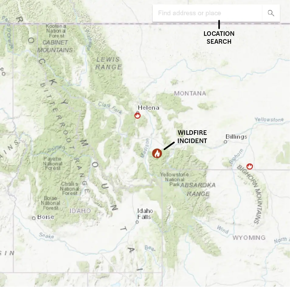
How to read the Idaho wildfire map
Use the search bar to enter your location, or zoom and scroll to explore the Idaho wildfire map. Map icons mark:
- Wildfire incident updates: Active Idaho fire incidents are shown with a flame icon and the name of the fire. Click on an incident for the timestamp of its most recent update.
- Perimeters: Fire perimeters are shown with a light red overlay and bold red outline. This is not a live map. While it’s updated regularly, wildfires can spread rapidly. Do not rely on this tracker for precise coverage.
- Hotspots: Thermal hotspots are shown as bright red dots. These hotspots may be the beginnings of wildfires. They may also be false positives due to other incidents, like volcanic activity, oil and natural gas wells, etc.
In addition to tracking fires in North Idaho and Southern Idaho, this map can be used to track wildfire activity nationwide.
Track Idaho fires near you
The Idaho wildfire map helps you track fire activity so you’re informed and prepared. Download the app on your phone to have ready access to critical information and key features.
Our Idaho wildfire tracker includes:
- Current fires
- Fire perimeters
- Evacuation warnings and orders
- Evacuation planning
- Smoke advisories
- Wind advisories
- Shelter locations


Getting help during Idaho forest fires
When you know where to turn, you can get help when you need it. These trustworthy resources are the best places to start:
- Idaho fire department directory
- 2-1-1 Idaho CareLine
- The Salvation Army Wildfire Relief
- Idaho Department of Lands’ recent wildfire alerts
- FEMA wildfire assistance
If you need help during an active wildfire or any other emergency, immediately call 911 first.
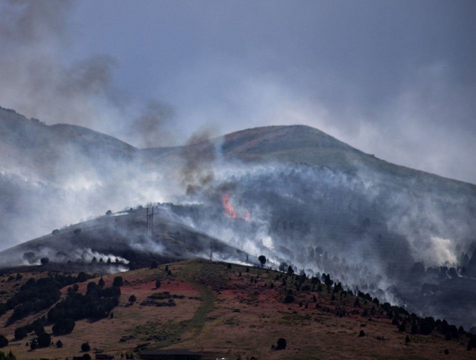
When is Idaho wildfire season?
The risk of fires in Idaho is highest between late spring and early fall. Wildfires are more common in June, peaking in July and early August.
When temperatures are high and humidity is low, the perfect conditions are set. With dry vegetation as fuel and a spark from lightning or human activity, wildfires can ignite and spread rapidly.
Patterns shift depending on the weather, with fire season becoming less predictable across the state.
Where you are in the state also affects your risk. The season for Idaho fires starts earlier in the range and shrublands. North Idaho fires tend to start later. The higher elevation makes Idaho forest fires less likely to start in the spring, when snow melt keeps fuels moist well into spring.
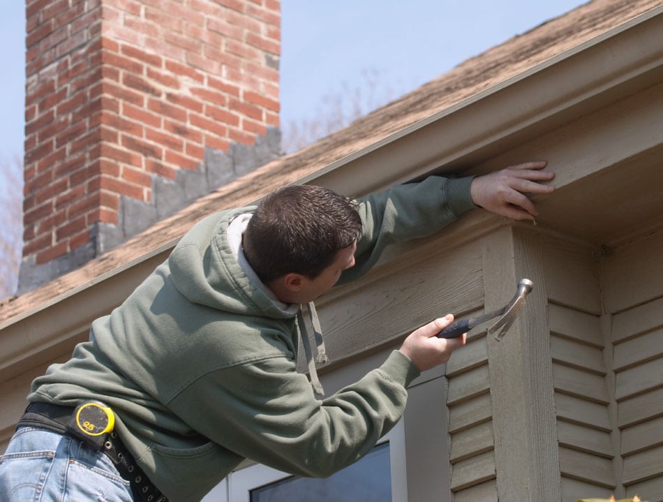
Preparing for Idaho wildfire season
Because wildfires are inevitable in Idaho, it pays to be prepared. Taking steps to harden your home and create defensible space around it can reduce the risk of drifting embers or fast-moving flames damaging your property.
These resources can help you make your property more fire-resilient and will help you best respond if a wildfire sparks in your area:
Keep track of Idaho fires to make safer decisions when wildfires are active near you. In addition to our Idaho fire map, you can use these resources to track smoke, weather conditions, and current fire movements:
Recovery after Idaho fires
Restoring your home and property after a wildfire and moving forward after a loss can be daunting. Understanding your insurance coverage, finding ways to finance a rebuild, and recovering emotionally are all vital steps in the process.
These resources can get you off to a solid start:
Idaho wildfire statistics per year
While California gets the headlines, Idaho fires have devastated communities here. The Island Creek Fire started at the end of July 2025 and raged into December. At least 14,943 acres have burned so far.
Other Idaho fires in 2025 include the Mire Fire, the East Fire, and the Elkhorn Fire. Fires in Idaho have scorched hundreds of thousands of acres in the last ten years.
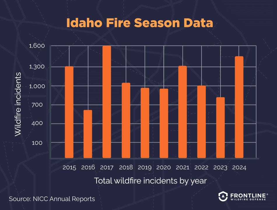
- 2024: 1,450 total wildfire incidents, 996,762 acres burned
- 2023: 892 total wildfire incidents, 87,801 acres burned
- 2022: 1,088 total wildfire incidents, 436,733 acres burned
- 2021: 1,332 total wildfire incidents, 439,600 acres burned
- 2020: 944 total wildfire incidents, 314,352 acres burned
- 2019: 960 total wildfire incidents, 284,026 acres burned
- 2018: 1,132 total wildfire incidents, 604,481 acres burned
- 2017: 1,598 total wildfire incidents, 686,262 acres burned
- 2016: 630 total wildfire incidents, 361,649 acres burned
- 2015: 1,324 total wildfire incidents, 804,094 acres burned
Source: NICC Annual Reports
What causes wildfires in Idaho?
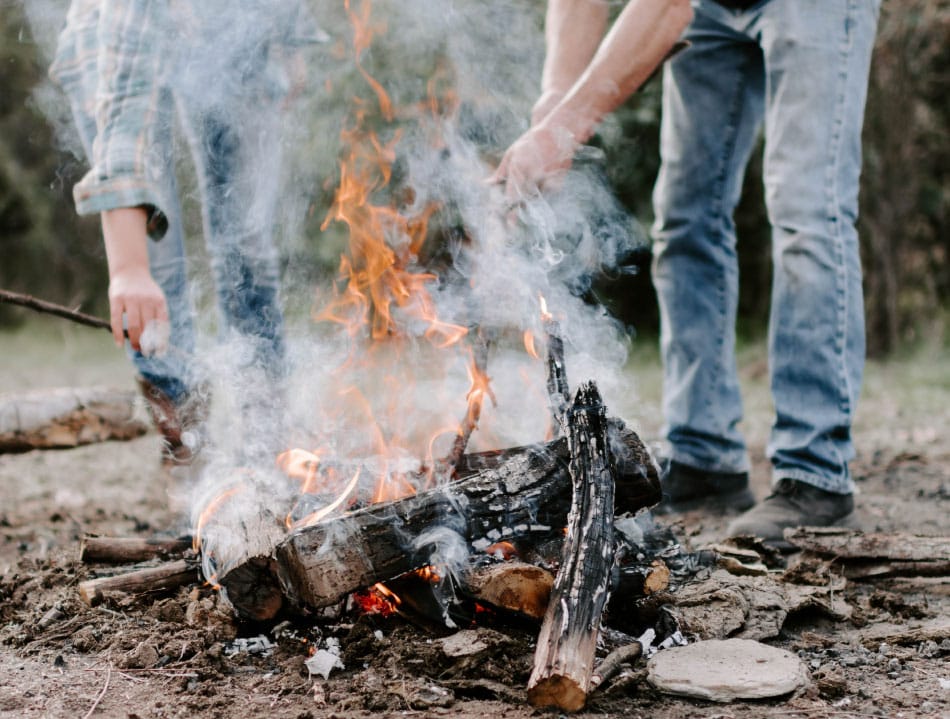
Humans are the leading cause of Idaho fires. Campfires that have been left to smolder, faulty equipment throwing off sparks, and fireworks are just some of the ways people start fires in Idaho. Added risk factors include:
- Drought: Lower-than-normal rainfall turns grasses, shrubs, and forests into dry fuel that can increase the length and severity of the Idaho fire season.
- High fuel density: Previous forest management policies designed to suppress natural fires have created dense and overgrown vegetation. Insects outbreaks, such as bark beetle infestations, have killed many trees in parts of Idaho. Once their needles fall, the dead trees can provide extra fuel and potentially contribute to larger or more intense wildfires, especially when combined with drought, high winds, or other ignition sources.
- Weather extremes: Higher temperatures combined with high winds and low humidity turn small fires into fast-moving blazes that consume many acres and are hard to contain.
- Storms with lightning: As the primary natural cause of wildfires, lightning in the backcountry and high elevations can spark multiple fires in a single storm.
- People and wildland-urban interface development: As more people move out of urban centers, they build homes and communities in fire-prone areas. Carelessness around campfires, equipment malfunctions, and other human activities is the top cause of wildfires.
- Topography and remoteness: Steep slopes that are far from roads and unreachable by firefighting equipment make it harder to contain fires. With little way to stop them, these can quickly expand in size and intensity.
FAQs
When was the largest wildfire in Idaho history?
The largest Idaho fire in history was the “Big Burn” of 1910. Sparked by lightning in August 1910 and driven by high winds, several small fires merged and spread across Idaho and Western Montana.
Millions of acres and dozens of timber towns were leveled, killing 87 people. The U.S. Forest Service was created as a result to manage wildlands and forest fires.
How common are wildfires in Idaho?
Wildfires are a common and natural part of Idaho’s ecosystem. Many forests and rangelands are in moderate-to-high-risk areas. A history of fire suppression, fuel buildup, and varying climate changes adds to the risk.
Fire readiness is a necessity. Experts at every level of the government urge residents to make their properties more fire resilient, be ready to evacuate, and be prepared to deal with the aftermath of fires.
Which Idaho areas are most prone to wildfires?
A quick look at an Idaho wildfire map of historical blazes would show that some regions of the state are more prone to fires. You’d also see that the start and end dates of the Idaho fire season vary based on terrain and geography.
Here are some general observations about wildfire risks in areas of the state:
- East-central Idaho: This region is home to expansive national forest lands interspersed with dry rangelands. Fast, large fires are common here.
- The Idaho panhandle: The higher elevations in this area attract snow that sticks around longer. When things do eventually dry out, the rugged terrain makes for fires that are hard to control.
- Southern Idaho: The grasses, sage, and invasive cheatgrass dry out early, fueling rapidly spreading fires.
- Central mountains and forests: Rugged landscapes and flammable conifer forests make for fires that can quickly spread and burn uncontained for months.
- Boise Valley: A wildfire in the populated foothills of Boise Valley burned 10,000 acres, showing that the city is not safe from fires, especially in the wildland-urban interface areas.
Make sure you have an Idaho fire map on your phone that’s updated regularly, so you can stay alert and aware.
Are wildfires affecting the insurance industry in Idaho?
Yes, wildfires are affecting the ability of homeowners to get insurance and afford coverage in Idaho. Some carriers are not renewing policies or cancelling coverage in the state. Others are pushing through large rate increases.
Idaho does not have a state-run FAIR Plan for basic coverage when private coverage is unavailable. Homeowners who invest in hardening their homes against wildfires may be more successful in getting affordable wildfire insurance coverage and may also be able to use alternatives.

Get ahead of the flames. Make the Frontline Defense System your wildfire plan.
Start protecting your home before the fire season begins with the Frontline Wildfire Defense System. Adding a proven layer of protection can save your home or reduce the damage when wildfires threaten.
Track Idaho fires in any county
Track fires in any of Idaho’s 40 counties with the Idaho fire map on the Frontline wildfire tracker app. The app makes it easy to track fires across the state, with a map of what’s happening near you.
Monitor fire perimeters, get updates, and keep tabs on fire impacts nearby. From Idaho Falls, Moscow, and Boise, to the north beyond Bonners Ferry and Sandpoint, see where Idaho fires are burning.
Ada County
Adams County
Bannock County
Bear Lake County
Benewah County
Bingham County
Blaine County
Boise County
Bonner County
Bonneville County
Boundary County
Butte County
Camas County
Canyon County
Caribou County
Cassia County
Clark County
Clearwater County
Custer County
Elmore County
Franklin County
Fremont County
Gem County
Gooding County
Idaho County
Jefferson County
Jerome County
Kootenai County
Latah County
Lemhi County
Lewis County
Lincoln County
Madison County
Minidoka County
Nez Perce County
Oneida County
Owyhee County
Payette County
Power County
Shoshone County
Teton County
Twin Falls County
Valley County
Washington County
About the Idaho Wildfire Tracker and Map
The Idaho wildfire map on this page displays the best-known locations and perimeters of active fires in Idaho. While elements in the wildfire map are updated daily, it should not be treated as a live wildfire map and is not intended to display evacuation routes.