Washington fire map & tracker
Stay up to date on the status of fires in Washington state with our Washington fire map and tracker app. Get real-time information on the location and status of fires, with links to help you respond quickly. It’s your go-to resource with all you need to stay safe during the Washington wildfire season.


Where are the fires in Washington state?
Having a Washington fire map available is the easiest way to keep tabs on fires in Washington state. The Frontline Wildfire Defense App shows you where WA wildfires are burning, their size, where they’re expected to spread, and their containment status.
Track Washington wildfires today with the interactive fire map on the free Frontline Wildfire Defense App (Android | iOS).
Take Steps Before the Next Fire
If you’re looking for a faster, safer, more precise way to protect your home during the Washington fire season, or any time during the year, we invite you to explore the Frontline Wildfire Defense System and get a quote for your property.
Protect your home today.
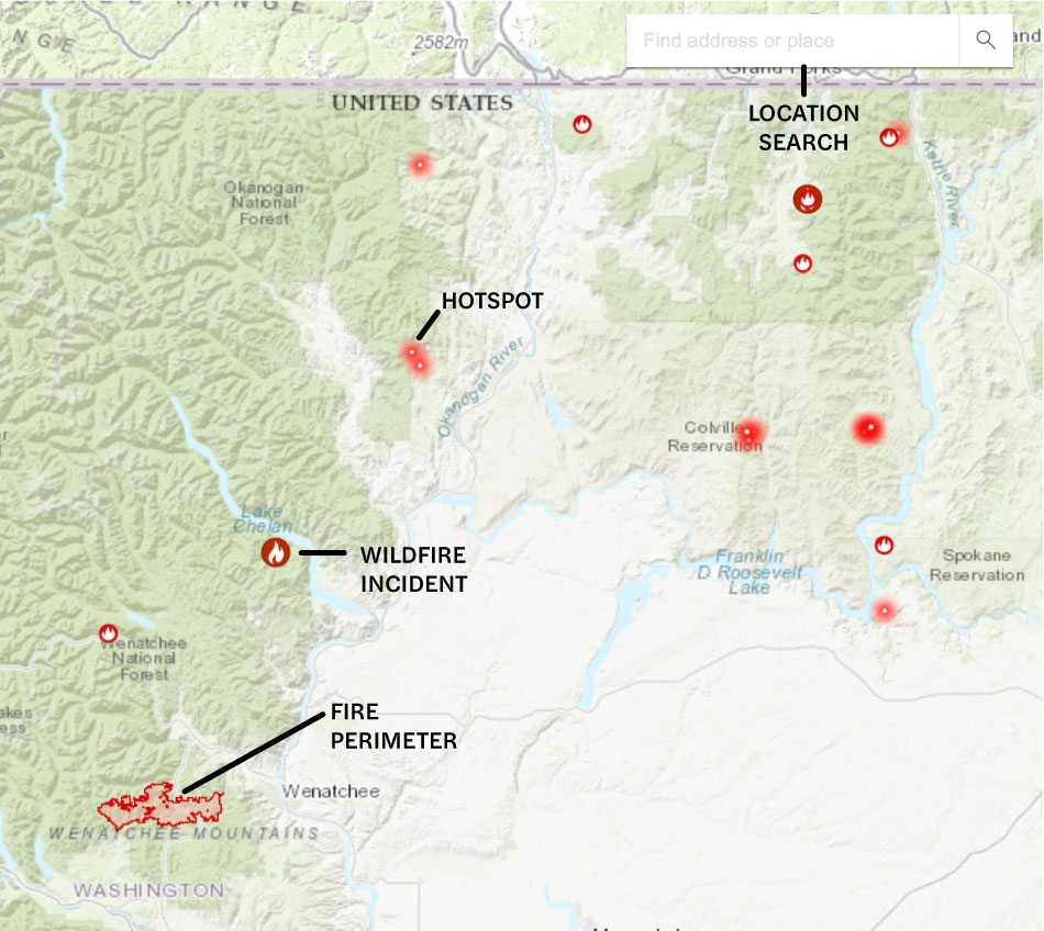
How to read the Washington wildfire map
Use the search bar to type in your location, or zoom and scroll to explore the Washington wildfire map. You’ll see several icons:
- Wildfire incident updates: Active Washington fires are displayed with a fire icon and the name of the fire. Click on an incident to see a timestamp of its most recent update.
- Perimeters: Fire perimeters are shown on the map with a light red overlay and bold red outline. This is not a live map. While it’s updated regularly, wildfires can spread rapidly. Do not rely on this tracker for precise coverage.
- Hotspots: Thermal hotspots are shown as bright red dots. These may be the beginnings of wildfires, or they may be false positives that the satellite picked up due to other incidents, like volcanic activity, oil and natural gas wells, etc.
In addition to tracking wildfires in Western Washington and Eastern Washington, this map can be used to track wildfire activity nationwide.
Track Washington fires near you
Our interactive Washington wildfire map and tracker gives you real-time information on Washington state fires, evacuation information, and local conditions, with links to helpful resources.
Our Washington wildfire tracker includes:
- Current fires
- Fire perimeter
- Evacuation warnings and orders
- Evacuation planning
- Smoke advisories
- Wind advisories
- Shelter locations


Get help during Washington state forest fires
When you’re affected by fires in Washington state, you need ready access to important resources. These links can connect you to help during and after a fire:
- WA 211 confidential statewide helpline
- FEMA wildfire assistance
- Northwest Interagency Coordination Center active fire information
Note: If you need help during an active wildfire or any other emergency, call 911 immediately.
When is wildfire season in Washington state?
Washington wildfire season runs mid-summer through mid-fall. Hot, dry conditions start in early July and continue through early October. There’s less rain during this time, so trees and vegetation dry out, creating fuel that a wildfire needs to start, intensify, and spread.
While fires are more likely during certain parts of the year, fires are a risk whenever the state experiences extended drought conditions.
Preparing for WA wildfire season
The steps you take before your property is at risk can make a big difference. These resources help you plan, with practical advice and steps you can take now:
It may be helpful to track WA air quality and current weather conditions to protect your health and safety. With an interactive fire map of Washington state and the following resources, you can actively monitor conditions:

Recovery after Washington fires
After a wildfire, you may need to restore and repair your property. Here are some resources to help you recover after a wildfire in Washington state:
Washington state wildfire statistics
WA wildfires burn thousands of acres in the state every year. Already in 2025, the Bear Gulch Fire consumed over 20,000 acres on the Olympic Peninsula. The Burdoin Fire near the Oregon border burned nearly 11,000 acres. You can track current wildfires in Washington state with a wildfire map.
Here’s a snapshot of Washington forest fires by year.
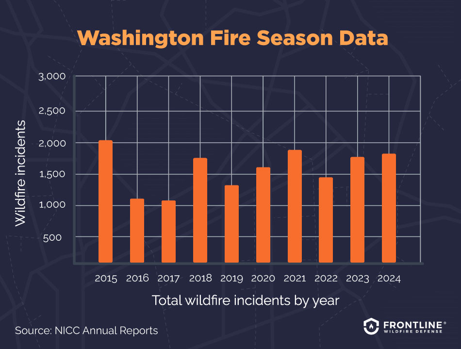
- 2024: 1,806 total wildfire incidents, 275,593 acres burned
- 2023: 1,707 total wildfire incidents, 151,316 acres burned
- 2022: 1,492 total wildfire incidents, 173,659 acres burned
- 2021: 1,863 total wildfire incidents, 647,222 acres burned
- 2020: 1,646 total wildfire incidents, 842,370 acres burned
- 2019: 1,394 total wildfire incidents, 169,742 acres burned
- 2018: 1,743 total wildfire incidents, 438,833 acres burned
- 2017: 1,246 total wildfire incidents, 404,223 acres burned
- 2016: 1,272 total wildfire incidents, 293,717 acres burned
- 2015: 2,013 total wildfire incidents, 1,137,664 acres burned
Source: NICC Annual Reports
What causes wildfires in Washington?
Several factors combine to spark a wildfire. The risk of wildfire in Washington is a matter of the climate and the condition of our wildland areas. Sadly, humans are often the primary cause of wildfires in Washington state. Other factors include:
- Rising temperatures: Warmer-than-average temperatures cause lower snowpack and earlier melt, creating an extended dry season.
- Longer summers: Longer periods of heat and low moisture dry out vegetation and soil, creating ideal conditions for a fire.
- Tree stress: Drought and heat stress trees, leaving them more vulnerable to insects and disease. Dead trees can fuel intense forest fires.
- Human activity: Whether due to ignorance, negligence, or malice, humans are a major cause of fires. Campfires that haven’t been put out, machinery that malfunctions and sparks, and deliberate arson are behind most fires. About 85% of WA wildfires are started by humans.
FAQs
When was the largest wildfire in Washington state history?
The Okanogan Complex Fire set the WA state record for the number of acres burned. Several smaller fires merged to scorch 304,782 acres in north-central Washington. A lightning strike on August 15, 2015, sparked the initial blaze that was fed by a heavy fuel load and high winds.
Why are there so many wildfires in Washington state now?
While Washington state has a reputation for being one of the wettest states in the country and is home to the Hoh Rainforest, climate change is affecting the ecosystem across the state. Lower precipitation and longer, hotter summers are increasing the risk of Washington forest fires. Add a growing population and increased human activity in dry areas, and you have the conditions for more frequent fires.
Which WA areas are most prone to wildfires?
Climate and ecology vary across the state. A Washington wildfire map will show more activity in the eastern half of the state. Yet climate change is affecting how you answer the question or where the fires in Washington state are. These impacts include:
- Eastern Washington: East of the Cascades is a mix of farmland, desert, and grasslands. It has a drier climate that is traditionally more prone to wildfire. An increasing population has heightened fire risk here.
- Western Washington: The western half of the state is undergoing changing weather patterns, with warmer temperatures and less rain than usual. Wildfires are a growing risk here.
Are wildfires affecting the insurance industry in Washington?
Yes, the growing number of fires in Washington state is affecting the insurance market. Getting insurance and finding affordable coverage is much more difficult, especially in high-risk areas. More homes are being considered at high risk across the state.
Like many states, Washington has a Fair Access to Insurance Requirements (FAIR) Plan. Homeowners who cannot get insurance through commercial insurers can get basic coverage under this plan. The downside is that limited coverage comes at a high cost.

Get ahead of the flames. Make the Frontline Defense System your wildfire plan.
Protect your property and loved ones before the Washington wildfire season starts. The Frontline Defense System allows homes to protect themselves the moment a wildfire threat is detected. This automated exterior sprinkler system is a fast, safe, and precise way to protect your property and have peace of mind.
Track Washington state fires in any county
Get important updates and detailed tracking for wildfires across Washington state. The interactive Washington fire map shows current wildfires in Seattle, Spokane, Yakima, and high-risk counties like Okanogan County. You’ll find the information you need regarding evacuation alerts and changing conditions in places like:
Adams County
Asotin County
Benton County
Chelan County
Clallam County
Clark County
Columbia County
Cowlitz County
Douglas County
Ferry County
Franklin County
Garfield County
Grant County
Grays Harbor County
Island County
Jefferson County
King County
Kitsap County
Kittitas County
Lewis County
Lincoln County
Mason County
Okanogan County
Pacific County
Pend Oreille County
Pierce County
San Juan County
Skagit County
Skamania County
Snohomish County
Spokane County
Stevens County
Thurston County
Wahkiakum County
Walla Walla County
Whatcom County
Whitman County
Yakima County
About the WA Wildfire Tracker and Map
The Washington wildfire map on this page displays the best-known locations and perimeters of active fires in Washington state. While elements in the wildfire map are updated daily, it should not be treated as a live wildfire map and is not intended to display evacuation routes.