Utah fire map & tracker
Get key information about wildfires in Utah with our Utah fire map and tracker app. You’ll see details about the location, size, and containment status of current fires in Utah, along with resources to help with decision-making and recovery.
From small towns and rural areas to big cities, this tool will keep you updated so you can stay safe and be prepared during the wildfire season.


Where are the fires in Utah?
Use our wildfire map and interactive app to find out if there’s a fire in Utah right now.
Up-to-date resources are essential for ensuring your family’s safety and protecting your property. Get detailed information about where Utah wildfires are, their size, their level of containment, and which areas are threatened by potential spread. When you know where the fires in Utah are located, you can make informed plans and fire-wise decisions.
Track Utah wildfires today with the interactive fire map or the free Frontline Wildfire Defense App (Android | iOS).
Take Steps Before the Next Fire
If you’re looking for a faster, safer, more precise way to protect your home during the Utah fire season, or any time during the year, we invite you to explore the Frontline Wildfire Defense System and get a quote for your property.
Protect your home today.
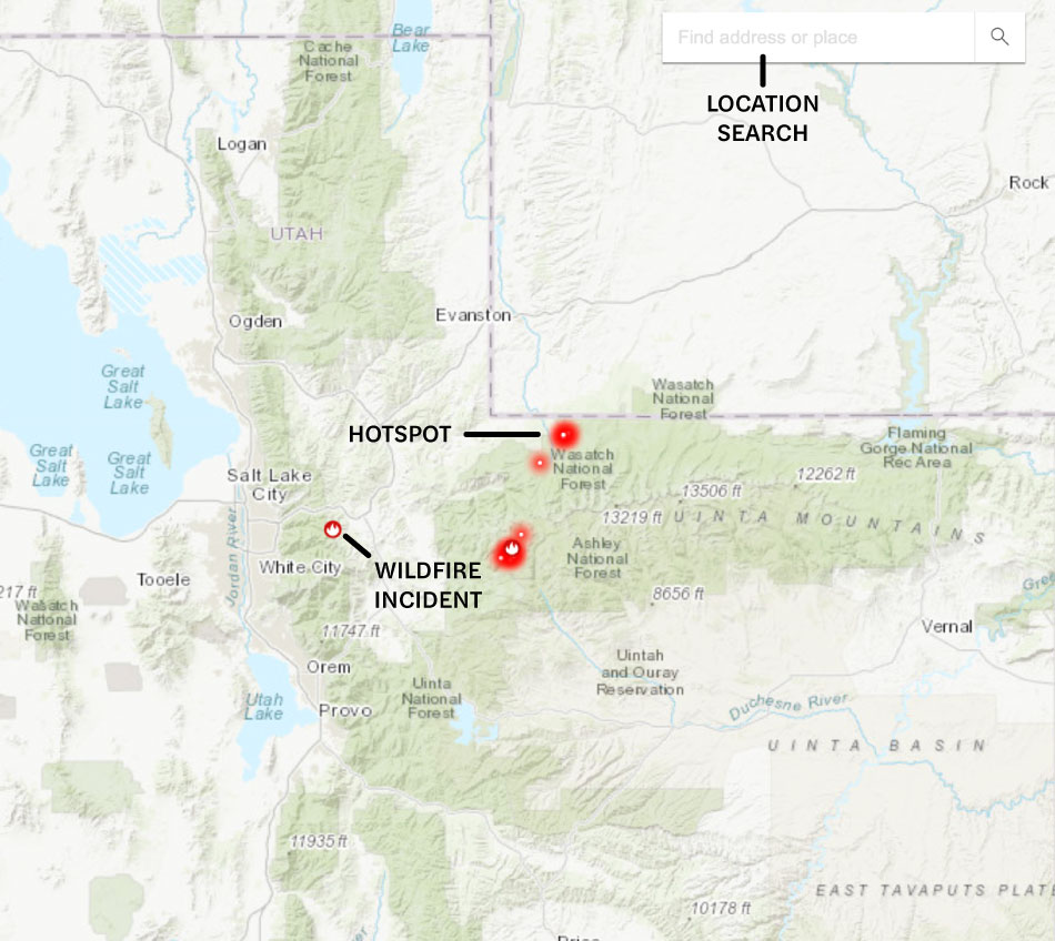
How to read the Utah wildfire map
Use the search bar to type in your location, or zoom and scroll to explore the Utah wildfire map. The map includes icons for:
- Wildfire incident updates: Active Utah fire incidents are displayed with a fire icon and the name of the fire. Click on an incident to see the timestamp of the most recent update.
- Perimeters: Fire perimeters are displayed on the map with a light red overlay and bold red outline. This is not a live map. While the map is updated regularly, wildfires can spread rapidly. Do not rely on this tracker for precise coverage.
- Hotspots: Thermal hotspots are shown as bright red dots. These can be the beginnings of wildfires, or they may be false positives that the satellite picked up due to other incidents, like volcanic activity, oil and natural gas wells, etc.
In addition to Western Utah and Eastern Utah wildfire tracking, this map can be used to track wildfire activity nationwide.
Track Utah fires near you
Monitor fires in Utah that are close enough to affect your health or threaten your property. The Frontline Utah fire map and tracker shows you the most complete and up-to-date information when you need it the most. You’ll have everything you need to stay aware and make informed decisions in one place.
Our Utah wildfire tracker includes:
- Current fires
- Fire perimeter
- Evacuation warnings and orders
- Evacuation planning
- Smoke advisories
- Wind advisories
- Shelter locations


Get help during Utah forest fires
If you’re impacted by active fires in Utah, reach out to these national, state, and local resources for information and help:
- Utah fire stations with the phone number of each
- FEMA wildfire assistance
- National Interagency Fire Center (NIFC) current fire conditions
- Utah fire resources
Note: If you need help during an active wildfire or any other emergency, call 911 immediately.
When is wildfire season in Utah?
The season when most Utah forest fires and wildfires start is generally July through October. During these months, much of the state is dry, the weather is hot, and windy conditions spread the flames.
The fire season varies by location. Fires in southern Utah start earlier and last longer, due to the pinyon-juniper woodlands and sagebrush in the desert climate. In the central and northern parts of the state, heavy snowfall protects higher-elevation forests.
Built-up areas, particularly in the wildland-urban interface, are increasingly threatened. The North Ogden Fire burned the foothills in 2025. Fires in both Provo Canyon and Springville burned in late summer 2025. Salt Lake City fire risks are on the rise, with a wildfire even burning near the state capitol building.
Preparing for Utah wildfire season
Planning and practical preparation can reduce wildfire risks and protect your home during a wildfire. These strategies and resources will help you face Utah wildfires with confidence:
Information helps keep you, your family, and your pets safe and healthy during the high season for wildfires in Utah. The following sites can help you track wildfire risks and monitor wildfire smoke in Utah, as well as track weather conditions:

Recovery after Utah fires
Coming back home after a wildfire in Utah can be overwhelming. Below are resources to help you take the next steps, guide you through options, and support rebuilding and financial recovery:
Utah wildfire statistics
Wildfires are a natural part of Utah’s ecosystem. They clear out undergrowth, help recycle nutrients in the soil, and help regenerate some types of plants and trees.
On average, 1,090 wildfires burn every year, with more during drought years.
So far, the 2025 Utah wildfire season has brought major wildfires, including the Monroe Canyon Fire, which destroyed 73,700 acres, and the Deer Creek Fire, which remained uncontained for a month, burning 17,724 acres.
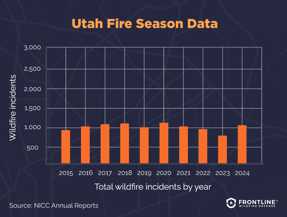
- 2024: 1,211 total wildfire incidents, 90,417 acres burned
- 2023: 782 total wildfire incidents, 18,109 acres burned
- 2022: 945 total wildfire incidents, 27,245 acres burned
- 2021: 1,085 total wildfire incidents, 60,863 acres burned
- 2020: 1,493 total wildfire incidents, 329,735 acres burned
- 2019: 1,025 total wildfire incidents, 92,380 acres burned
- 2018: 1,333 total wildfire incidents, 438,983 acres burned
- 2017: 1,166 total wildfire incidents, 249,829 acres burned
- 2016: 1,078 total wildfire incidents, 101,096 acres burned
- 2015: 930 total wildfire incidents, 10,203 acres burned
Source: NICC Annual Reports
What causes wildfires in Utah?
Wildfires in Utah are driven by a mix of dry conditions, high winds, and human activity. On the Utah wildfire map, you can see how these factors shape where and how fires spread across the state.
Here’s a closer look at some of the major environmental risk factors creating conditions for fires in Utah:
- Rising temperatures: Utah has seen hotter, drier conditions over the last few decades. Dry vegetation and dry soil create the ideal environment for wildfires.
- Record drought: Less rain and snow across the state have worsened the problem of dry vegetation. The Great Salt Lake is at a historically low level.
- Invasive plants: Non-native plants that are not adapted to the climate, like cheatgrass, dry out faster and lead to a buildup of flammable fuel across the landscape.
- Extreme weather and high winds: High winds can quickly spread wildfires.
FAQs
When was the largest wildfire in Utah history?
Utah’s largest wildfire started near the town of Milford, in west-central Utah, in July 2007. Known as the Milford Flat Fire, it caused significant damage to the area’s environment and economy and forced Interstate 15 to close. It burned over 363,000 acres before being finally extinguished.
Are wildfires in Utah more common now?
Yes, several factors are making fires in Utah more common today. As more people settle in the state, human-caused wildfires are on the upswing. Add in climate change and its resulting hot, dry conditions, and you have the recipe for rising wildfire risks.
Which areas of Utah are most prone to wildfires?
Expanding human settlement on the outskirts of major cities is putting people and homes in the path of wildfire danger. The wildland-urban interface, where homes and nature collide, is growing quickly.
The Wildfire Risk Assessment Portal for Utah notes that the Wasatch Front, particularly neighborhoods spreading up into canyons, is at the greatest risk of danger. The southern part of the state, particularly desert areas, is most vulnerable.
Are wildfires affecting the insurance industry in Utah?
Yes, wildfire risks are dramatically changing the Utah property insurance market. The cost of fires in California is being spread to customers everywhere. Premiums are going up (over 40% in a year in some places). If you’re in a high-risk area, you may find your insurance company is dropping your coverage.
Utah does not have a FAIR Plan option for basic fire insurance coverage for those unable to find insurance in the commercial market. Homeowners may struggle with getting coverage. Learning from California’s insurance options can help homeowners in high-risk areas uncover options.

Get ahead of the flames. Make the Frontline Defense System your wildfire plan.
Be ready before the Utah wildfire season starts. Frontline’s automated sprinkler system can be remotely activated the moment a wildfire threat is detected, protecting your home and property from approaching embers. Discover how proactive fire protection works and can give you lasting peace of mind.
Track Utah fires in any county
Use the Frontline Utah wildfire map and tracking app to locate active fires in Utah. If you live in or travel through vulnerable areas like Salt Lake City, Springville, Ogden, Provo Canyon, ski resort areas, or the natural wonders in Southern Utah, the interactive Utah fire map is invaluable.
The app covers all Utah counties, including:
Beaver County
Box Elder County
Cache County
Carbon County
Daggett County
Davis County
Duchesne County
Emery County
Garfield County
Grand County
Iron County
Juab County
Kane County
Millard County
Morgan County
Piute County
Rich County
Salt Lake County
San Juan County
Sanpete County
Sevier County
Summit County
Tooele County
Uintah County
Utah County
Wasatch County
Washington County
Wayne County
Weber County
About the Utah Wildfire Tracker and Map
The Utah wildfire map on this page displays the best-known locations and perimeters of active fires in Utah. While elements in the wildfire map are updated daily, it should not be treated as a live wildfire map and is not intended to display evacuation routes.