Arizona fire map & tracker
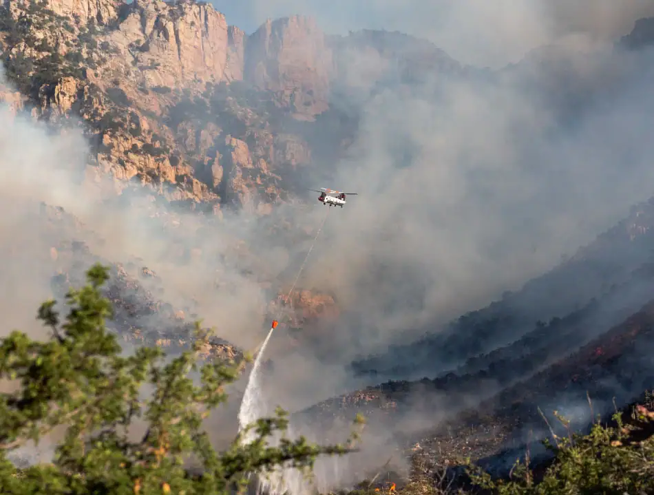
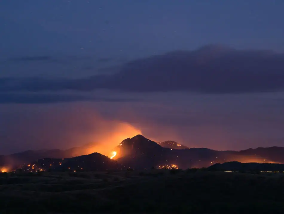
Arizona faces wildfire threats each year, especially during the dry, hot months and monsoon-season lightning storms. Our Arizona fire map and tracker can help you monitor current fire activity and stay aware of changing conditions. Use the tools below to stay informed, get prepared, and protect your home and family.


Where are the fires in Arizona?
Frontline Wildfire’s Arizona fire map helps you keep track of where wildfires are actively burning in the state. The information is updated daily, allowing you to make informed decisions about your home and family if a fire threatens your area.
Having access to regular updates about fire activity and air quality can help you with vital planning, ensuring you take the right steps at the right time.
Track fires in Arizona with our interactive fire map or the free Frontline Wildfire App (Android | iOS).
Take Steps Before the Next Fire
If you’re looking for a faster, safer, more precise way to protect your home during the Arizona fire season, or any time during the year, we invite you to explore the Frontline Wildfire Sprinkler System and get a quote for your property.
Protect your home today.
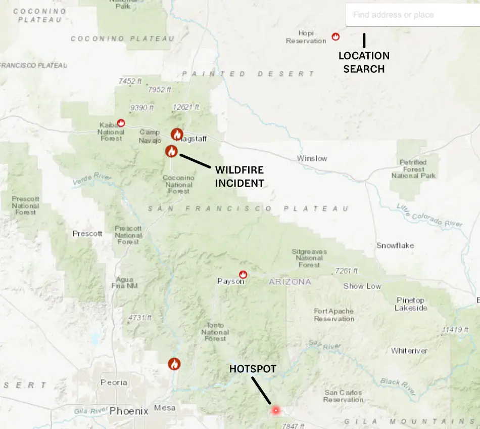
How to read the Arizona wildfire map
Use the search bar to enter your location, or zoom and scroll to explore the Arizona wildfire map. The map displays icons representing:
- Wildfire incident updates: Active Arizona fire incidents are indicated by a fire icon and the name of the fire. Click on an incident to reveal the time of the most recent update.
- Perimeters: Fire perimeters are shown with a light red overlay and bold red outline. Please note that this is not a live map. While it’s updated regularly, wildfires can spread rapidly, so don’t rely solely on this tracker for precise information.
- Hotspots: Thermal hotspots are displayed as bright red dots. These hotspots could indicate the beginnings of wildfires, or they may be false positives from other heat sources, such as volcanic activity and oil and natural gas wells.
In addition to tracking fires in Northern Arizona and Southern Arizona, this map can be used to monitor wildfire activity nationwide.
Track Arizona fires near you
Stay connected to vital information with our Arizona wildfire map and comprehensive phone app. These tools give you the details you need to stay prepared, take action, and make the right decisions.
Our Arizona wildfire tracker includes information on:
- Current fires
- Fire perimeters
- Evacuation warnings and orders
- Evacuation planning
- Smoke advisories
- Wind advisories
- Shelter locations


Getting help during Arizona forest fires
If you’re affected by Arizona wildfires, knowing where to get help is essential for your safety and ability to respond effectively to the threat. Useful contacts include:
- Arizona fire departments (contact details by county)
- 211 Arizona Information and Referral Service
- The Salvation Army
- Arizona Wildfire Watch
- FEMA Wildfire Assistance
Note: If you need help during an active wildfire or any other emergency, call 911 immediately.
When is wildfire season in Arizona?
Wildfires in Arizona are most common in spring and early summer. While Arizona doesn’t have a fixed wildfire season, fires often begin in March, with risk increasing through April, May, and June. However, the risk of fire exists year-round, especially in times of drought.
Preparing for Arizona wildfire season
Anticipate the risks of Arizona forest fires so you’re ready long before the first spark. You can take practical steps in advance to reduce your risk and protect your property, such as:
The first step to being prepared is staying informed. When facing active fires in Arizona, having the right information is vital for making decisions that keep you, your family, and your property safe. These resources can help you track current fires in Arizona and monitor air quality:

Recovery after Arizona fires
After a fire has passed, feelings of uncertainty, stress, and loss can create a state of turmoil, but having clear guidance and trustworthy support can help. These resources can help you take the first steps toward recovery:
Arizona wildfire statistics per year
Wildfires in Arizona are a natural part of the state’s ecology. Although these fires are a fact of life, fire risk varies from year to year. In 2025, Arizona saw one of the largest fires in the state’s history, the Grand Canyon Fire, which burned over 145,504 acres and destroyed the Grand Canyon Lodge.
While there haven’t been any recent major Phoenix fire incidents or a notable fire in Mesa, both areas are suffering extreme drought and are at risk. You can use our Arizona fire map to help you track fires in both high- and low-risk years. Here’s a look at Arizona’s wildfire statistics over the past decade:
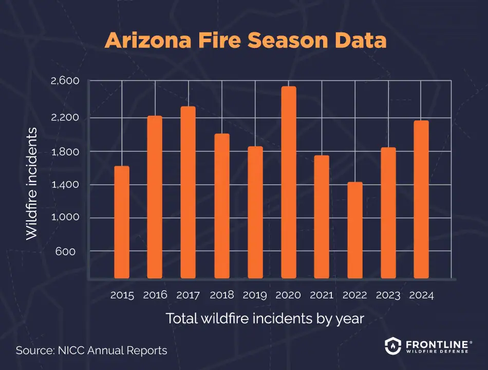
- 2024: 2,191 total wildfire incidents, 282,989 acres burned
- 2023: 1,837 total wildfire incidents, 188,483 acres burned
- 2022: 1,432 total wildfire incidents, 124,165 acres burned
- 2021: 1,773 total wildfire incidents, 524,428 acres burned
- 2020: 2,524 total wildfire incidents, 978,567 acres burned
- 2019: 1,869 total wildfire incidents, 384,942 acres burned
- 2018: 2,000 total wildfire incidents, 165,356 acres burned
- 2017: 2,321 total wildfire incidents, 429,564 acres burned
- 2016: 2,288 total wildfire incidents, 308,245 acres burned
- 2015: 1,662 total wildfire incidents, 160,152 acres burned
Source: NICC Annual Reports
What causes wildfires in Arizona?
Looking at the Arizona wildfire map and the history of fires across the state reveals certain patterns. A combination of natural and human factors contributes to the risk of Arizona wildfires. Key drivers of wildfires in Arizona include:
- Humans: Unfortunately, people are the leading cause of Arizona wildfires. Many fires result from improperly extinguished campfires, burning debris, fireworks, malfunctioning equipment and vehicles, and even sparks caused by dragging trailer chains.
- Dry climates and drought: Certain areas, such as the southwest of the state, are naturally drier than others. Fires in Northern Arizona, an area that normally gets more snow and rain, are more likely to occur during long periods of low precipitation.
- Fuel availability: Arizona forest fires burn hotter when woodland landscapes are not thinned out. In other areas, dried invasive buffelgrass and nonnative plants can create a buildup of highly combustible dead vegetation.
- Weather and terrain: Dry lightning storms can spark fires, with high winds fanning the flames and spreading embers. Steep slopes make it easier for fire to spread faster.
- Wildland-urban interface: Rapid development in Arizona has led to homes and communities being located at the outskirts of nature, close to forests, brush, grasslands, and open desert, where they are more at risk of fire. Fire can spread quickly from wild areas to residential areas.
FAQs
When was the largest wildfire in Arizona history?
The largest wildfire in Arizona history was the Wallow Fire in the eastern part of the state. It started on May 29, 2011, and swept across the White Mountains. It destroyed 538,049 acres before it was fully contained on July 8.
Is Arizona prone to wildfires?
Wildfires are common in Arizona, affecting various regions across the state. In the desert, they’re fed by dry, hot conditions, as well as invasive plants that can increase fire risk. In the forested northern part of the state, dense stands of trees that haven’t been thinned in years create a fire risk, particularly during times of drought.
An Arizona wildfire map will show variation in the number of fires each year, depending on the conditions. Humans, however, remain the primary cause, responsible for sparking around 90% of wildfires.
What areas of Arizona are at high fire risk?
High-risk fire areas in Arizona include neighborhoods adjoining wildland areas that are dense with vegetation and those affected by hotter, drier conditions. Notable high-risk fire areas include:
- Phoenix: While wildfires in Phoenix are rare, the number of buildings in the city makes their impact potentially devastating.
- Prescott: Many neighborhoods in Prescott extend into the high-risk wildland-urban interface.
- Flagstaff: The forests surrounding the city have heavy fuel loads and are historically prone to fire.
- Oak Creek Canyon, Mescal, and Ramsey Canyon: Although not as urbanized, these areas are in some of the highest-risk fire areas in Arizona.
Are wildfires affecting the insurance industry in Arizona?
Wildfires in Arizona are affecting the insurance market by driving up premiums, limiting coverage options, and causing some carriers to withdraw from certain high-risk areas entirely. The Arizona Department of Insurance and Financial Institutions cites an increase in the number and severity of fires, along with more communities being built in the wildland-urban interface, as factors driving up insurance costs.
Arizona doesn’t have an insurer-of-last-resort option or FAIR plan that homeowners can turn to. As a result, when homeowners in Arizona lose coverage, they may struggle to find a replacement policy.

Get ahead of the flames. Make the Frontline Defense System part of your wildfire plan.
In Arizona, wildfire risk is driven by drought, wind, and fast-moving fires that can leave little time to react. Most homes aren’t lost to direct flames, but to wind-driven embers that can ignite roofs, decks, vents, and other vulnerable areas.
Frontline addresses this risk with an automated exterior sprinkler system that can be remotely activated as wildfire conditions escalate, wetting vulnerable surfaces around the home to help reduce the chance of ignition.
Track Arizona fires in any county
The Frontline Wildfire Arizona fire map and wildfire tracker make it easy to find out where fires are burning across the state — from Phoenix to Flagstaff and Tucson, and from the New Mexico border to the Colorado River. Details are updated daily for all of Arizona’s 15 counties:
Apache County
Cochise County
Coconino County
Gila County
Graham County
Greenlee County
La Paz County
Maricopa County
Mohave County
Navajo County
Pima County
Pinal County
Santa Cruz County
Yavapai County
Yuma County
About the Arizona Wildfire Tracker and Map
The Arizona wildfire map on this page displays the best-known locations and perimeters of active fires in Arizona. Keep in mind that while elements in the wildfire map are updated daily, it should not be treated as a live wildfire map and is not intended to display evacuation routes.