New Mexico fire map & tracker
Having a New Mexico fire map at hand will give you up-to-date and essential information about nearby risks and conditions. The Frontline Wildfire Tracker app provides daily updates about the location, size, perimeter, and status of any fire in New Mexico.


Is there a fire in New Mexico?
New Mexico wildfires are unpredictable. Conditions can change quickly, particularly when it is dry and winds are strong. Having a daily-updated New Mexico wildfire map on your phone can keep you informed about any active fires in New Mexico, with vital information about where they are, how big they are, and the information and advisories officials have shared.
Track fires in New Mexico with the interactive fire map or the free Frontline Wildfire App (Android | iOS).
Take Steps Before the Next Fire
If you’re looking for a faster, safer, more precise way to protect your home during the New Mexico fire season, or any other time during the year, we invite you to explore the Frontline Wildfire Defense System and get a quote for your property.
Protect your home today.
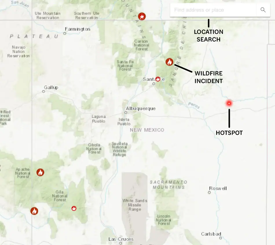
How to read the New Mexico wildfire map
Use the search bar to type in your location, or zoom and scroll to explore the New Mexico wildfire map. Map icons cover:
- Wildfire incident updates: Active New Mexico fire incidents are displayed with a fire icon and the name of the fire. Click on this for a timestamp of its most recent update.
- Perimeters: Fire perimeters are displayed on the map with a light red overlay and bold red outline. This is not a live map. While it’s updated regularly, wildfires can spread rapidly. Do not rely on this tracker for precise, current coverage.
- Hotspots: Thermal hotspots are shown as bright red dots. These hotspots could be the beginnings of wildfires, or they may be false positives that the satellite picked up due to other incidents, like volcanic activity or oil and natural gas wells.
In addition to tracking fires in New Mexico, you can use this map to track wildfire activity nationwide.
Track New Mexico fires near you
Our New Mexico fire map tells you about more than where fires are burning in the state. You get comprehensive fire and safety information all in one place to help you stay prepared.
Our New Mexico wildfire tracker includes:
- Current fires
- Fire perimeter
- Evacuation warnings and orders
- Evacuation planning
- Smoke advisories
- Wind advisories
- Shelter locations


Getting help during New Mexico forest fires
If a fire in New Mexico is active near you, getting as much current information as possible can help keep you prepared and in control. These organizations can help with fire updates, emergency assistance, and post-fire recovery:
Remember, if you need help during an active wildfire or any other emergency, you should call 911 immediately.
When is wildfire season in New Mexico?
New Mexico wildfires can start at any time of year; however, they occur more often during late spring and early summer. May and June in particular are when fires in New Mexico are most likely.
The heavy rainfall during the monsoon months in late June and July reduces fire risk. In recent years, we have seen longer, drier fire seasons, with significant risk year-round. Our New Mexico fire map can help you keep track of what is happening near you every day so you can stay vigilant.
Preparing for New Mexico wildfire season
Take steps now to reduce your risks and improve the fire resilience of your property. These resources can help you prepare for the next New Mexico wildfire season:
Staying informed is just as important as preparing your property and making safety plans. Use the following links to monitor wildfire activity, air quality, and changing fire weather conditions in New Mexico:

Recovery after New Mexico fires
If your property has been affected by fire in New Mexico, you are likely facing the challenge of recovery. The resources below can help you with making short-term decisions, answering financial questions, rebuilding long-term, and getting emotional support:
New Mexico wildfire statistics
Annual New Mexico wildfire data tells the story of increasing wildfire activity in the state. The 2025 New Mexico wildfire season was an active one, driven by drought, low humidity, and high winds. The Trout Fire in Grant County burned through 47,000 acres in July, while the nearby Buck Fire torched 57,753 acres between its start on June 11 and containment 67 days later.
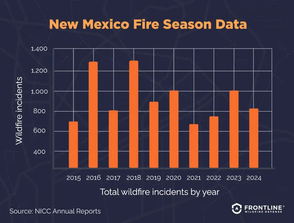
- 2024: 823 total wildfire incidents, 82,531 acres burned
- 2023: 1,019 total wildfire incidents, 212,378 acres burned
- 2022: 748 total wildfire incidents, 859,906 acres burned
- 2021: 672 total wildfire incidents, 123,792 acres burned
- 2020: 1,018 total wildfire incidents, 109,512 acres burned
- 2019: 859 total wildfire incidents, 79,887 acres burned
- 2018: 1,334 total wildfire incidents, 382,344 acres burned
- 2017: 813 total wildfire incidents, 141,663 acres burned
- 2016: 1,240 total wildfire incidents, 212,425 acres burned
- 2015: 696 total wildfire incidents, 44,104 acres burned
Source: NICC Annual Reports
What causes wildfires in New Mexico?

New Mexico’s semi-arid climate, ongoing droughts, and year-round high winds mean the state faces fire risks beyond the typical dry-summer season seen in other Western states. Several additional factors also contribute to New Mexico’s elevated wildfire risk, including
- Human activity: Many New Mexico fires are caused by people. Campfires left burning, sparks from vehicles and equipment, fireworks, and other human causes spark many accidental ignitions.
- Dry climate: Much of the state is arid or semi-arid desert. Long stretches without rain mean grasses, shrubs, and trees become the ideal fuel for forest fires in New Mexico. It doesn’t take much for a fire to start and rapidly spread.
- Weather extremes: High winds are normal for New Mexico. Combined with low humidity, they can fan flames and push them across wide expanses quickly.
- Rising temperatures: Changes in the climate are making New Mexico’s dry climate even drier. Fires are more intense and spread farther.
- Vegetation build-up: Over the decades, aggressive firefighting has led to the accumulation of dense underbrush and standing dead trees. With so much fuel, a small fire can quickly escalate into an inferno.
FAQs
When was the largest wildfire in New Mexico’s history?
The largest fire in New Mexico’s history was a man-made disaster that occurred in the Sangre de Cristo Mountains in 2022. A pile burn in Calf Canyon joined with a U.S. Forest Service prescribed burn in Hermit’s Peak and grew out of control. It consumed 500 square miles or 342,000 acres and destroyed 903 structures.
The initial fire started on April 6 and was over 90% contained by April 22. Unfortunately, high winds gusting over 70 mph whipped the flames over an extraordinarily dry landscape into an out-of-control disaster. It was not until the end of August that the fire was finally put out.
Are wildfires in New Mexico becoming more common?
Yes, wildfires in New Mexico are a growing concern. Increasing drought and dryness have extended the New Mexico fire season to a year-round risk. Fire activity was up in 2025, continuing a decades-long trend. As well as an increase in the overall number of fires, 2025 saw some of the largest fires in the state and fires starting earlier in the year.
Which areas of New Mexico are at high fire risk?
The risk of fire in Albuquerque, Santa Fe, and the Los Alamos region remains high. As development continues in the wildland-urban interface areas and forested mountain regions, more homes and infrastructure are being built in high-risk areas where fire is a regular and natural part of the ecosystem.
You can better prepare and protect your property when you know the specific risks of your area. Find these risks by checking the New Mexico Wildfire Risk Portal.
Are wildfires affecting homeowners’ insurance in New Mexico?
Yes, wildfires are driving up insurance rates in New Mexico. Increased fire risks are leading some companies to cancel or decline to renew existing policies. New Mexico lawmakers are looking for ways to bring relief to property owners and to stabilize the insurance market. New Mexico’s Fair Access to Insurance Requirements (FAIR) Plan is a way for property owners to obtain basic insurance coverage if they cannot get a plan from a commercial insurance company.
Unfortunately, the FAIR plan option is expensive and may not cover all the costs of rebuilding after a fire in New Mexico. You can learn more about wildfire insurance on our wildfire insurance guide.

Get ahead of the flames. Make the Frontline Defense System your wildfire plan.
Be ready before the New Mexico wildfire season starts. Frontline’s automated sprinkler system can be remotely activated the moment a wildfire threat is detected, protecting your home and property from approaching embers.
Discover how proactive fire protection works and can give you lasting peace of mind.
Track New Mexico fires in any county
Our New Mexico fire map and tracker provides up-to-date information on active wildfires across the entire state, with coverage spanning all 33 counties, including:
Bernalillo County
Catron County
Chaves County
Cibola County
Colfax County
Curry County
De Baca County
Doña Ana County
Eddy County
Grant County
Guadalupe County
Harding County
Hidalgo County
Lea County
Lincoln County
Los Alamos County
Luna County
McKinley County
Mora County
Otero County
Quay County
Rio Arriba County
Roosevelt County
Sandoval County
San Juan County
San Miguel County
Santa Fe County
Sierra County
Socorro County
Taos County
Torrance County
Union County
Valencia County
About the New Mexico Wildfire Tracker and Map
The New Mexico wildfire map on this page displays the best-known locations and perimeters of active fires in New Mexico. Keep in mind that while elements in the wildfire map are updated daily, it should not be treated as a live wildfire map and is not intended to display evacuation routes.