Wyoming fire map & tracker
Our Wyoming fire map shows where fires are active and provides information about areas of the state that are prone to wildfires. The following resources will help you stay alert, ready, and safe.


Where are the fires in Wyoming?
The rich upland forests and dry, semi-arid climate make wildfires in Wyoming unavoidable. Where they spark and how they spread can change quickly, making a Wyoming wildfire map invaluable.
The map gives you more than just the basics. It’s updated daily with information on active fires, including their sizes, perimeters, and containment statuses, as well as the locations of hotspots. You can zoom in to get accurate information, allowing you to monitor the situation and plan accordingly.
Track fires in Wyoming with the interactive fire map or the free Frontline Wildfire Defense App (Android | iOS).
Take Steps Before the Next Fire
If you’re looking for a faster, safer, more precise way to protect your home during the Wyoming fire season, or any time during the year, we invite you to explore the Frontline Wildfire Defense System and get a quote for your property.
Protect your home today.
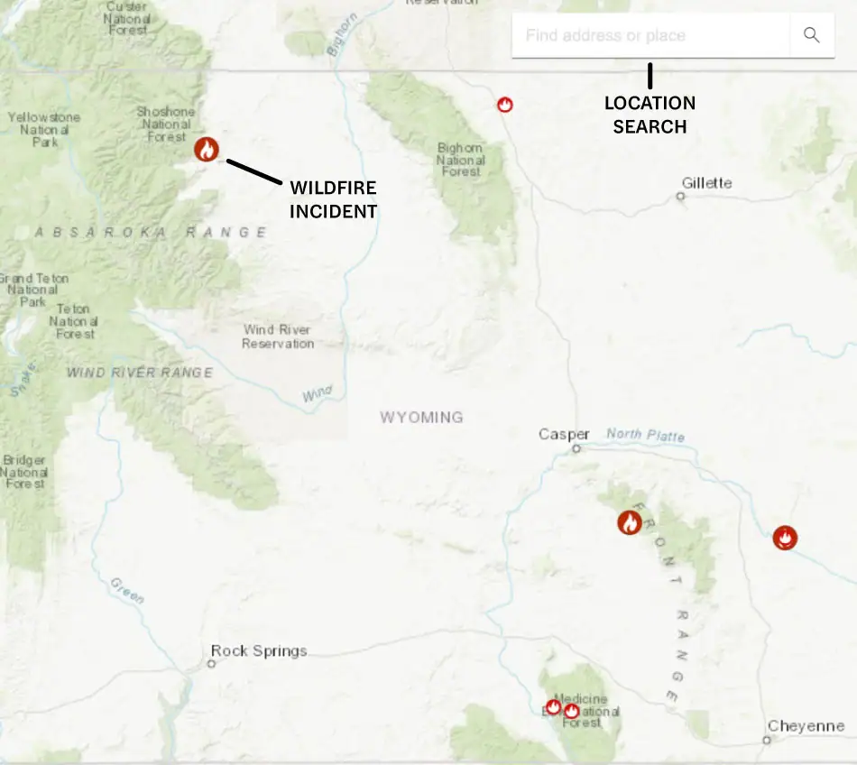
How to read the Wyoming wildfire map
Use the search bar to type in your location, or zoom and scroll to explore the Wyoming wildfire map. Map icons cover:
- Wildfire incident updates: Active Wyoming fire incidents are displayed with a fire icon and the name of the fire. Click on an incident for the timestamp of its most recent update.
- Perimeters: Fire perimeters are marked with a light red overlay and bold red outline. This is not a live map. While it’s updated regularly, wildfires can spread rapidly, so don’t rely on this tracker for precise, current coverage.
- Hotspots: Thermal hotspots are shown as bright red dots. These could be the beginnings of wildfires, or they may be false positives that the satellite picked up due to other incidents, like volcanic activity or oil and natural gas wells.
In addition to tracking fires in Wyoming, you can use this map to track wildfire activity nationwide.
Track Wyoming fires near you
Our app does more than chart Wyoming wildfires. It provides critical updates and safety information so you can access everything you need in one place and stay prepared.
Our Wyoming wildfire tracker includes:
- Current fires
- Fire perimeters
- Evacuation warnings and orders
- Evacuation planning
- Smoke advisories
- Wind advisories
- Shelter locations


Getting help during Wyoming forest fires
There are various local, state, and national resources that can offer information and assistance during wildfires. These include:
- Wyoming fire departments, including phone numbers
- Wyoming 211 CareLine
- The Salvation Army
- FEMA wildfire assistance
Remember, if you need help during an active wildfire or any other emergency, you should call 911 immediately.
When is wildfire season in Wyoming?
The Wyoming wildfire season starts in late spring, with July and August having the highest number of wildfires. As temperatures rise, trees, grasses, and brush dry out, becoming ideal fuel for fires. This is why wildfires in Wyoming increase in number and intensity from late summer through early fall.
The Wyoming wildfire season traditionally ends in early October. However, the effects of climate change have extended the season. In dry years, the risk of wildfires can start in early April and run through December.
It’s important to stay alert to fire danger year-round, not just during the peak months. A Wyoming wildfire map is an invaluable tool that informs you about fires in the state at any time of the year, helping you to better prepare and protect your home.
Preparing for Wyoming wildfire season
Preparing for the possibility of wildfires in Wyoming entails reducing risks to your property year-round. A fire map of Wyoming is also essential for knowing when immediate danger is approaching. Resources that offer practical advice for improving your readiness include:
Information is the key to advancing readiness and facing fires in Wyoming. These state and national resources can help you keep track of weather conditions, air quality, and active fires in Wyoming:
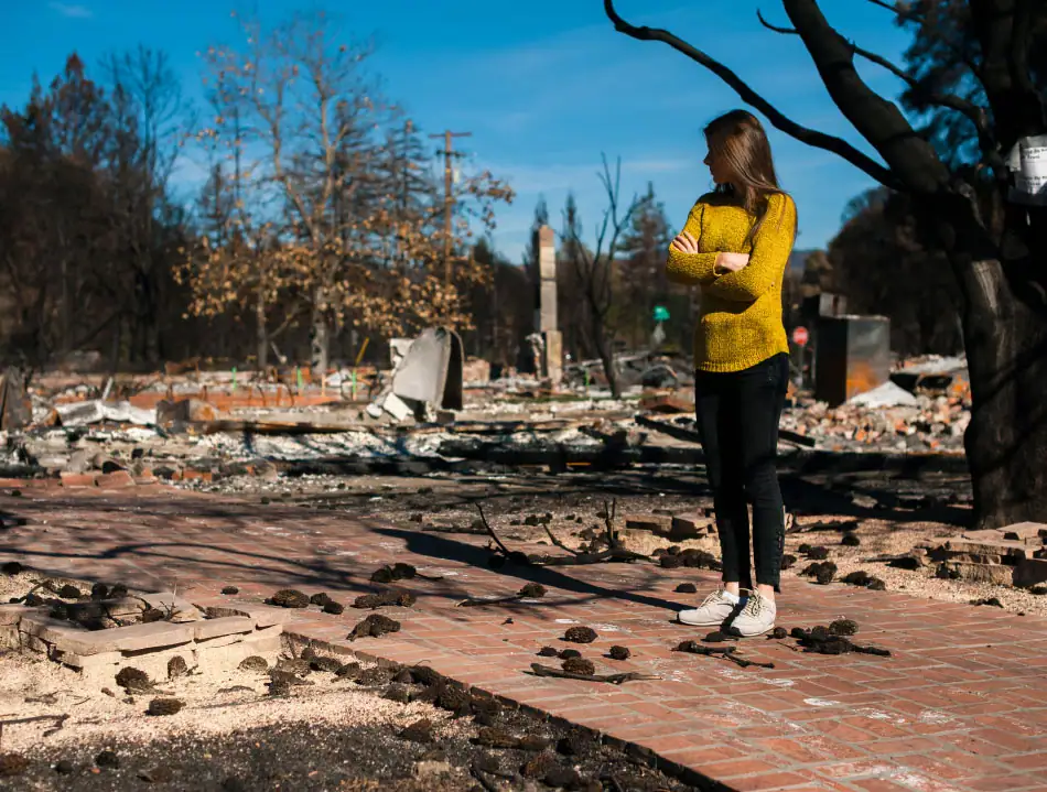
Recovery after Wyoming fires
Should a wildfire impact your property, you may face a long, expensive, and emotionally difficult path to recovery. The following resources can help guide you through the steps and make the process more manageable:
Wyoming wildfire statistics
A Wyoming fire map can tell you what is happening now, but looking at the history of wildfires in Wyoming can help you learn about potential risks.
Wildfire activity varies year to year depending on weather, fuel conditions, and sources of ignition. 2025 saw significant burns from the Red Canyon Fire, the Sleeper Ranch Fire, and smaller fires that together scorched over 250,000 acres.
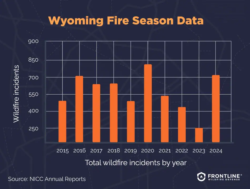
- 2024: 738 total wildfire incidents, 620,069 acres burned
- 2023: 249 total wildfire incidents, 7,934 acres burned
- 2022: 443 total wildfire incidents, 25,766 acres burned
- 2021: 540 total wildfire incidents, 53,496 acres burned
- 2020: 828 total wildfire incidents, 339,782 acres burned
- 2019: 486 total wildfire incidents, 41,857 acres burned
- 2018: 611 total wildfire incidents, 279,242 acres burned
- 2017: 599 total wildfire incidents, 90,115 acres burned
- 2016: 711 total wildfire incidents, 218,077 acres burned
- 2015: 512 total wildfire incidents, 35,652 acres burned
Source: NICC Annual Reports
What causes wildfires in Wyoming?
Across the Wyoming wildfire map at any given time, you’ll find blazes caused by both natural and human actions. Understanding the risk factors can help you predict, prepare for, and potentially reduce the danger of wildfires. These include:
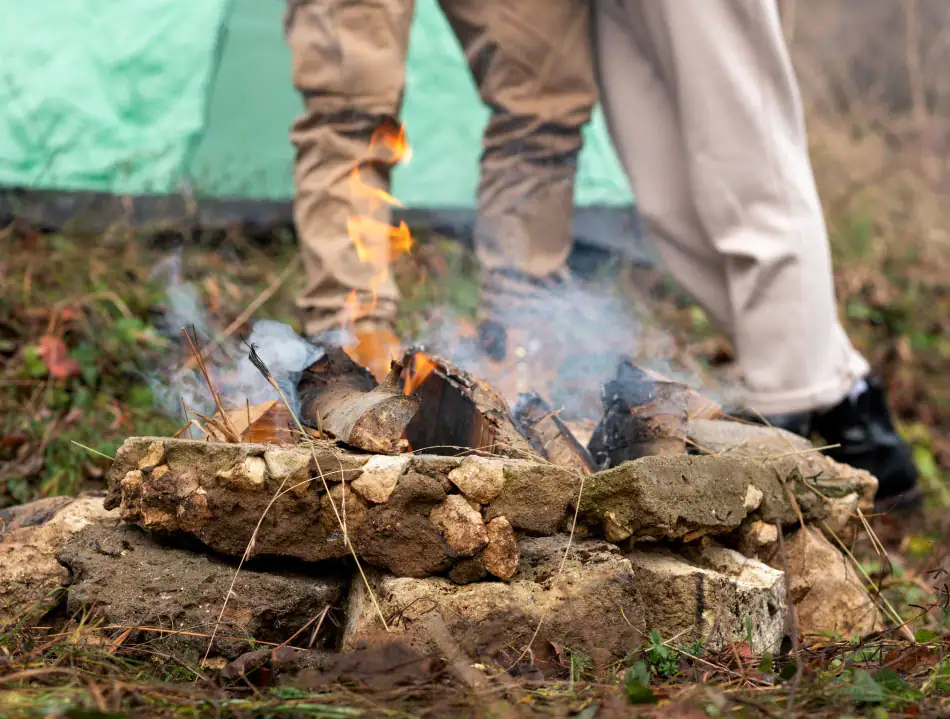
- Human activity: Too many wildfires are sparked by human carelessness. Malfunctioning equipment and vehicles, campfires left undoused, fireworks, and discarded cigarettes can all start a fire in the right circumstances. Over 70% of wildfires in Wyoming are human-caused.
- Weather: Hot and dry conditions that parch grasses, brush, and trees provide fuel. Lightning, particularly dry lightning without rain, can spark a fire, and high winds can quickly spread it.
- Dense vegetation: Overgrown forests and grasslands, along with dead standing trees left from insect infestations, provide ideal conditions for feeding fires.
- Wildland-urban interface: Building at the edge of communities places structures near areas with abundant flammable vegetation, making them fire-prone. Access for firefighters and firefighting infrastructure may also be limited in these areas.
FAQs
When was the largest wildfire in Wyoming’s history?
The largest fire in Wyoming’s history occurred in 2020. The Mullen Fire consumed 176,878 acres near Laramie and spread into parts of Colorado between starting on Sept. 17, 2020, and reaching 97% containment on Jan. 4, 2021.
What started the fire remains unknown, but an infestation of mountain pine and spruce beetles left plenty of dry, standing dead trees for fuel. Wind gusts topping 70 miles per hour spread the fire with alarming speed. The cost of fighting the fire reached $41.2 million, with costs for destroyed property and the damaged ecosystem exceeding that.
Is Wyoming at risk for wildfires?
Wildfires are common in Wyoming and are a natural part of the state’s ecology. From spring through fall, hot, dry conditions increase fire risk. Though fires in places like California make the headlines, the per-home and per-community risk is often greater in Wyoming, particularly for homes near open prairies and forests prone to fire. Wyoming’s various ecosystems and landscapes, built-up fuel from past wildfire suppression efforts, and changing climate patterns are leading to more frequent and intense fires.
Which areas of Wyoming are at high fire risk?
If you’re wondering where the fires in Wyoming are, start by looking at the high-risk areas. Risks are greater where people and buildings meet fire-prone landscapes, often called the wildland–urban interface. Development near and within forests and grasslands is more vulnerable and harder for firefighters to defend.
The mountainous areas of the state also face higher risks due to dense fuel buildup, steep slopes, dry weather patterns, and limited access to areas where fires start. National forests including the Bridger‑Teton, Shoshone, and Bighorn fall within this risk area.
How are wildfires affecting insurance coverage in Wyoming?
Wildfires are affecting the insurance market in Wyoming as they do in other high-fire-risk states. Property owners are seeing higher insurance costs as underwriters assess risk and set premiums.
Higher claims in other states are affecting the costs to Wyoming property owners, potentially leading some companies to decide not to renew coverage. Wyoming does not have a state-sponsored insurance program, such as a FAIR Plan, that provides basic coverage for property owners who can’t secure insurance from other sources. You can learn more about your insurance options and premiums in our wildfire insurance resource.

Get ahead of the flames. Make the Frontline Defense System your wildfire plan.
Be ready with a plan and an active defense system in place before the Wyoming wildfire season starts. Frontline’s automated sprinkler system can be remotely activated the moment a wildfire threat is detected, protecting your home and property from approaching embers.
Track Wyoming fires in any county
Our Wyoming wildfire map lets you view active fires across all 23 counties and zoom in to track wildfire activity near your location or anywhere in the state.
Albany County
Big Horn County
Campbell County
Carbon County
Converse County
Crook County
Fremont County
Goshen County
Hot Springs County
Johnson County
Laramie County
Lincoln County
Natrona County
Niobrara County
Park County
Platte County
Sheridan County
Sublette County
Sweetwater County
Teton County
Uinta County
Washakie County
Weston County
About the Wyoming Wildfire Tracker and Map
The Wyoming wildfire map on this page displays the best-known locations and perimeters of active fires in Wyoming. Keep in mind that while elements in the wildfire map are updated daily, it should not be treated as a live wildfire map and is not intended to display evacuation routes.